Since its launch in 2015, PRAPS has implemented significant initiatives to improve pastoral conditions, including livestock vaccination campaigns, infrastructure (water points, livestock markets, veterinarian units, vaccination parks) development, and sustainable resource management.
During its first phase, PRAPS lacked a real-time monitoring and evaluation (M&E) system, leading to significant delays in project implementation and unmet targets. In response, the PRAPS Regional Coordination Unit partnered with Bluesquare to develop a technological solution for efficiently tracking key project indicators. This initiative led to the creation of a monitoring and evaluation platform and a cartographic portal, combining data analytics and GIS for improved decision-making.
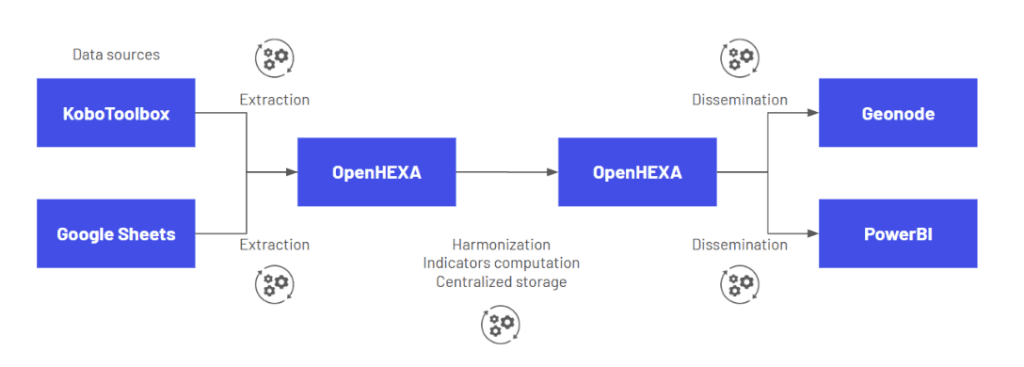
To ensure optimal project monitoring, Bluesquare used OpenHEXA to deploy a solution composed of:
- A centralized database with automated data extraction and consolidation, collecting and structuring data from two sources: KoboToolbox (over 10 forms) and Google Sheets, with automated data pipelines via OpenHexa. Data collected through Kobo forms filled out in the field is automatically cleaned and integrated into a single database, allowing M&E specialists at the country level to access the most up-to-date data at any time.
- Interactive dashboards in PowerBI, offering a dynamic visualization of project indicators with specific filters by time and countries.
- A cartographic portal via Geonode, displaying infrastructure progress and other key geographic data.
This solution was developed through close collaboration between Bluesquare experts, the PRAPS Regional Coordination Unit, and technical teams from the six participating countries. Additionally, Bluesquare’s use of open-source technology ensures the platform’s long-term sustainability and adaptability.